Boundary Surveys
 One of the most important services our company provides is the boundary survey. The purpose of a boundary survey is to reestablish and/or recover the property corners of a piece of property and accurately define the limits of the subject property. Property lines are identified on our final survey drawing using a system called “metes and bounds”. Bearings accurate to one second of arc and distances to the nearest one hundredth of a foot are calculated for all boundary courses and depicted on our final drawing. The process of determining these boundaries is a very involved process. The outline below details the typical procedure for a boundary survey:
RESEARCH
The first step towards determining the boundaries for a parcel of land involves research. We research many areas, but the most common area of research is the pubic records stored at The Clerk of Superior Court for the applicable county. We will also obtain any right-of-way plans from the Department of Transportation for any adjoining road rights-of-way. Additionally, we will interview the property owner and the adjacent owners for any and all information, including deeds, unrecorded plats, or parole evidence, that may assist us in arriving at our final analysis of the boundary location. We also often rely on information that can be obtained from a title inspection report for the subject property. The title inspection report is usually provided by the client and is required if the boundary survey is being done to ALTA/NSPS standards.
FIELD MEASUREMENTS
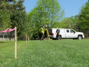
After the research is complete, our next step is to visit the site with our equipment and accurately measure the location of all field evidence. We will diligently search for monuments at all property corners. We will look especially hard for monuments that are referenced in our research, as well as for “uncalled” for monuments. “Monuments” usually are iron pins, concrete monuments, trees, and/or stones. We will locate other evidence of ownership, such as fences, walls, hedges, etc. Improvements near property lines will be located as well to confirm whether encroachments exist. All property corners will be visibly flagged and marked with a stake upon completion of our survey. (Sometimes we may have to visit the subject property twice if many corners are missing or other problems exist).
OFFICE ANALYSIS / DRAWING PREPARATION
The final step in the preparation of a Boundary Survey is the analysis of our field data as compared to our research. We will analyze calculated and measured distances and compare them to the research, attempting to determine the final location of all boundary lines. A drawing will be prepared and delivered to the client detailing all appurtenant information related to the boundaries of the subject property. If necessary, we will meet with the client to discuss problem areas and possible courses for problem resolutions.
We offer various levels of this type of survey. If you simply need your corners marked for a fence or other purpose, or are missing one of you corners, you may want a reduced level service.


